fbpx

Field Notes


Dams On the Upper Green River Would Be Bad For Wyoming

Upper Green River, Wyoming

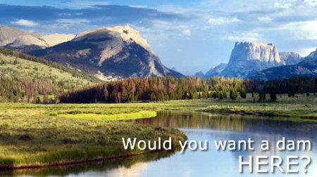
The Wyoming Outdoor Council asks for your help in telling Governor Mead that new dams, particularly two suggested on the Upper Green River, are not the answer to water security in Wyoming and should not be a part of the final Wyoming Water Strategy.

  • Warren Bridge Dam Permitting would be an initiative to begin the permitting and planning stage for a large dam on the Upper Green River near the Warren Bridge. The structure would be capable of 50,000 to over 150,000 acre-feet of capacity.
  • Green River Lakes Reservoir would be an initiative to begin the exploratory agreement and planning phase for a large dam and reservoir, likely in excess of 200,000 acre-feet in capacity, on the Upper Green River near or inside the National Forest Boundary.

The Outdoor Council believes more secure water supplies will come with proactive management decisions that stem from access to good information and lead to greater water conservation and resource protection. Construction of new dams does not fit within that framework.

New dams on the Upper Green would negatively impact fish and wildlife populations, destroy riparian areas, impede necessary fish passage, block a crucial wildlife migration corridor, and degrade the river downstream of them. Dams would additionally encroach upon valuable livestock grazing lands and popular hunting and fishing grounds.

Impacts to Wild and Scenic Qualities

The upper 41 miles of the Green River (from its source above Green River Lakes to the Forest boundary) have been determined by the Forest Service to have “outstandingly remarkable values” for designation as a Wild and Scenic River (USFS, Wild and Scenic River Eligibility Evaluation, Bridger-Teton National Forest). Building a dam near or above the Forest Boundary would degrade this quality.

Fisheries Habitat

Significant impacts would occur to fisheries habitat from flooded riparian areas, increased water temperatures, and decreased dissolved oxygen levels. Higher water temperatures pave the way for toxic events such as algal blooms, which further drive down dissolved oxygen levels as the organic matter decomposes, that ultimately result in “dead zones” where fish and other aquatic life cannot survive.

Migration Corridor

Map Courtesy of The Wildlife Conservation Society

Especially notable, is that the river corridor of the Upper Green provides a regionally important migration route for wildlife, particularly for pronghorn that winter in the Upper Green River Basin and migrate north toward Jackson for the summertime (USFS, Wild and Scenic River Eligibility Evaluation, Bridger-Teton National Forest). The path that the pronghorn take along the Upper Green River travels through both suggested dam sights and is part of one of the longest large mammal migration corridors in North America. The section where the Green River Lakes Reservoir would be located is known as “the funnel” of the migration corridor. This is where a narrow water gap was created by the Green River and where pronghorn numbering in the hundreds must travel each spring in order to make their way further north. Damming this area would impose yet another obstacle, a likely impassible one, for a vital migration route already threatened by oil and gas development further south in the Upper Green River Basin. If this happens, pronghorn will likely disappear from valuable places such as the scenic Grand Teton National Park (“Pronghorn Migration on The Path of the Pronghorn,” Wildlife Conservation Society).

Downstream Impacts

Additionally, downstream from either of these suggested dams, the Green River itself as well as other existing dams would continue to see impacts.  Dams are finite structures and cannot function in perpetuity. As the river velocity decreases approaching a dam, sediment and debris naturally carried by the river are dropped resulting in siltation at the mouth of the reservoir. Siltation is an inevitable occurrence and will eventually fill the reservoirs behind the dam. Siltation can happen more quickly in areas with more debris and sand for the river to carry, further decreasing the lifespan of a dam.

When debris is trapped behind a dam, siltation is not the only problem. Riverbeds downstream become stripped of the organic materials that would normally flow into and through them. Trapped debris can no longer create wildlife and water insect habitat in the river corridor nor enrich soils along the riverbank. With fewer structural materials such as logs and rocks to slow the river in places, a stripped stream bed results in enhanced erosion of the downstream river channel. In turn, unnaturally high erosion can result in excessive sediment loads traveling downstream to be stopped behind the next dam and contributing to siltation there. As you can see, the impacts of dams are increased not just to rivers, but other infrastructure too as more dams are placed along a river channel.

Significant impacts to fish and wildlife and further degradation of the already imperiled larger Colorado River Basin are not the solutions to our water concerns. In fact, they will likely only exacerbate them. Please help us deliver this message by August 4th, 2014 and ask Governor Mead not to pursue dams on the Upper Green River.

For questions please contact Amber Wilson, Environmental Quality Coordinator at amber@wyomingoutdoorcouncil.org or 307-332-7031 (ext. 20)


Field Notes


Guest Column: Part II — Applying lessons learned to protect people in new boom areas from air pollution

Note: The Wyoming Outdoor Council has partnered with Environmental Defense Fund in an effort to help the state of Wyoming protect the public from dangerous air pollution in the Upper Green River Basin—and beyond.

This guest column by EDF’s Jon Goldstein provides some insight into how we might apply some lessons learned to protect people who live and work in new drilling boom areas.

Wyoming’s Opportunity to Head off Pollution at the Pass

frackingwyo_92689731_rf_0By , EDF | Bio | Published: July 11, 2014

Yesterday we explored how Wyoming regulators and Governor Mead are making progress on a set of potentially strong air pollution measures in Pinedale and across the Upper Green River Basin of Southwestern Wyoming.

But today a similar drilling boom is happening in Converse and Campbell counties in the northeast area of the state. Unfortunately, none of these strong, sensible new air pollution requirements apply in these areas.

The numbers are stark. A full 80 percent of the current drilling in Wyoming is occurring out in the part of the state with the least restrictive air quality controls. The U.S. Bureau of Land Management is currently beginning a process to consider as many as 5,000 new oil and gas wells in Converse County alone, and equal or greater drilling activity is expected in neighboring Campbell County over the next decade.

Historically, Wyoming has focused its best air quality controls in the areas with the most drilling. In the past this has meant the state has implemented controls in the southwest corner of the state that led the nation. This has included requiring reduced emission “green completions” on new oil and gas wells, frequent inspections using accurate, instrument-based technologies to detect and fix pollution leaks, and requiring cost-effective, nationally leading controls on things like pumps, glycol dehydrators and tanks that are among the largest sources of harmful pollution.

It’s now time for the state to continue this tradition by expanding these sensible pollution control requirements statewide in order to capture the new drilling hotspots.

Fortunately, state regulators have an excellent playbook that could be quickly implemented statewide. The strong, sensible controls the state is in the process of implementing across the UGRB could be quickly implemented on a statewide basis. New areas feeling the brunt of the boom in oil and gas drilling should benefit from the lessons the state has learned in the Upper Green River Basin.

Taking these pollution controls statewide will help level the playing field for producers and offer the same strong level of health protection to all Wyoming residents. They also make good business sense.

It’s a fact that it is almost always less expensive to prevent pollution than it is to clean it up. The state, therefore, has an opportunity here to apply cost-effective pollution controls upfront and do it right from the start.

And many of these technologies would actually save the industry money over time.  A recent report that EDF commissioned from the independent consulting firm ICF International shows that approximately 40 percent of hydrocarbon emissions from the nation’s oil and gas sector could be eliminated by 2018 at a total cost of just one penny per thousand cubic feet of gas produced. So, not only are these controls good for local air quality and the health of residents, they are good for the production companies’ bottom lines as well.

In the third reel of westerns, impending problems were often narrowly averted when the heroes saddled up and headed them off at the pass. When it comes to protecting air quality and the health of residents, that’s exactly the same opportunity the Cowboy State has here. Regulators, let’s ride.

– See more at: http://blogs.edf.org/energyexchange/2014/07/11/wyomings-opportunity-to-head-off-pollution-at-the-pass/#sthash.KJnh4kr8.dpuf

Field Notes


Guest Column: Part I — A Promising proposal for fixing air pollution in the Upper Green

Note: The Wyoming Outdoor Council has partnered with Environmental Defense Fund in an effort to help the state of Wyoming protect the public from dangerous air pollution in the Upper Green River Basin—and beyond.

This guest column by EDF’s Jon Goldstein provides an excellent overview of the state’s newly proposed pollution controls, as well as some specifics about how these controls might be improved. Securing good rules for the Upper Green will be the first step toward better protecting everyone in Wyoming.

A Wyoming Two Step for Better Air Pollution Controls

By , EDF | Bio | Published: July 10, 2014

By G. Thomas at en.wikipedia

Wyoming is a national energy leader, producing more BTU’s from federal lands than every other state combined. It also has a long history of leading the nation on smart, sensible oil and gas air pollution regulations. The Cowboy State was among the first to require reduced emission completions (RECs or “green” completions) to control emissions from newly drilled oil and gas wells. It has also implemented some of the country’s best requirements to find and fix leaky oil and gas equipment.

The state now has an opportunity to continue this tradition by tightening controls on existing oil and gas pollution sources in the Upper Green River Basin. Draft rules recently released by the state show promise, and with key improvements–including expanded leak inspections and extending emission controls to compressor stations–these new requirements could again emphasize the state’s role as a national leader on oil and gas regulation.

Writing rules well is an essential ingredient to stay at the front of the pack; so is making sure that the rules are effective when applied. Currently, Wyoming’s air rules apply differently in different parts of the state, and in areas where the majority of the drilling takes place the least protective air rules apply. Wyoming has an opportunity to demonstrate its leadership again but it needs to adopt both robust air quality controls that work and implement comprehensive requirements that apply equally statewide.  All residents should have the benefit of cleaner air.

There’s great potential for the Cowboy State to take a Wyoming two-step toward better air regulations. Over the next two days, we’ll explore the steps involved, starting first with how Wyoming can improve poor air quality conditions in the Upper Green River Basin (UGRB).  

Tackling Wyoming ozone pollution

For several years Wyoming environmental regulators, industry and local residents have been grappling with a serious air pollution problem in Pinedale and surrounding Sublette, Sweetwater and Lincoln counties. A huge boom in oil and gas drilling in the UGRB led to harmful ozone levels breaking federal health-based limits. At times, Pinedale’s approximately 1,400 residents had to deal with smog levels rivaling those in famously polluted Los Angeles.

This oil and gas pollution has real health impacts including heightened risks of respiratory disease, especially in children and the elderly. And it’s a problem in Wyoming. A recent scientific study conducted by the Wyoming Department of Health showed that more Sublette County residents seek medical help for respiratory ailments on days with higher ozone pollution levels. In 2012, due to this unhealthy air, the UGRB was listed as a federal nonattainment area for ozone pollution and Sublette County has received “F” grades in several annual “State of the Air” reports by the American Lung Association.

To their credit, Governor Mead and his staff have tackled this problem head on. The state spearheaded a task force with local citizens and oil and gas producers to come up with a consensus plan for reducing air pollution. And the state has made good headway on implementing this plan, instituting strong air pollution controls on new and modified sources in the basin last summer, including some of the nation’s best requirements for regular leak inspections to detect and fix problems with leaky oil and gas drilling and production equipment.

The latest step could be their strongest yet, putting in place sensible, enforceable rules to reduce pollution from existing oil and gas sources in the basin. Rules that could translate into significant reductions in volatile organic compounds (VOCs), hazardous air pollutants (HAPs) and methane pollution. This will be the first time Wyoming has implemented regulations to tighten controls on existing sources of air pollution from the oil and gas sector and their willingness to do so highlights the technical, economic and political feasibility of these sorts of smart pollution control measures.

Improvements, however, are still needed to ensure these rules are as beneficial as necessary. For instance, these requirements could and should:

  • Require frequent instrument-based leak inspections. The state is currently proposing a two-tiered approach: quarterly visits at sites that produce emissions above 4 tons per year (tpy) and annual, instrument-based inspections at sites with emissions below 4 tpy. Unfortunately, based on the state’s own data of the 5,075 facilities in the UGRB, this would mean only 143 facilities (less than 3 percent) will receive the more robust quarterly inspections. These lower emitting sites may be smaller, but in aggregate they can mean a lot of VOC and methane pollution. For instance, again using state data, the 143 higher emitting facilities may be responsible for as little as 725 tons/yr of VOC emissions. Meanwhile the other 4,932 smaller sites might be responsible for between 4,932 and 14,796 tons/yr of harmful emissions – potentially as much as the VOC emissions from all the cars and trucks on the road in Wyoming. Performing these inspections more than once a year will help catch more leaks faster and therefore better reduce this harmful pollution.
  • Include compressor stations that can leak harmful oil and gas pollution. The most recent state emissions inventory indicates that compressor stations emit more than 1,500 tons of VOCs per year. If the rules are not strengthened to include compressor stations, they could potentially represent the largest source of unaddressed emissions in the basin.
  • Do not allow combustors that control emissions from pumps and dehydrators to be removed. These are two of the largest sources of VOC and methane pollution in the basin, and control devices are an effective tool in reducing their pollution. Once installed, these combustors should be kept in place to do their job as the state currently requires for new and modified dehydrators in the Jonah-Pinedale Anticline Development portion of the UGRB.

And it should be noted, as illustrated in a recent report from business consulting group ICF International, many of these pollution controls are extremely cost effective.

EDF will remain involved in this issue and advocate for these improvements on Monday as the state’s Air Quality Advisory Board considers these rules and later in the fall as they are expected to go before the Wyoming Environmental Quality Council.

It is good to see the state working to require commonsense, cost-effective air pollution control measures across the basin. Next, the state should make them apply across the state to head off the potential for similar pollution problems before they occur.

– See more at: http://blogs.edf.org/energyexchange/2014/07/10/a-wyoming-two-step-for-better-air-regulations/#sthash.RyQB3NXY.dpuf

Field Notes


MEDIA RELEASE: BLM Issues Balanced Plan for the Wind River Basin

Storm over Beaver Rim, Wyoming. Photo copyright Scott Copeland Images.

FOR IMMEDIATE RELEASE

June 26, 2014

Media Contacts:
Julia Stuble, Wyoming Outdoor Council, 307-332-7031 x11, julia@wyomingoutdoorcouncil.org
Scott Kane, Lander resident, Owner, Creative Energies, 307-349-4052, scott@CEsolar.com

BLM Issues Balanced Plan for the Wind River Basin

LANDER — The Bureau of Land Management issued its new long-term land-use plan for the Lander Valley and Wind River Basin on June 26 — and the Wyoming Outdoor Council believes it is one of the most balanced plans yet created in Wyoming.

The new land-use plan will guide management of 2.4 million acres of federal surface and 2.8 million acres of federal mineral estate for the next 15 to 20 years.

The plan encompasses the Sweetwater Watershed — which contains some of the last intact sections of the Oregon, Mormon, and California National Historic Trails — as well as the Upper Wind River Valley, which is popular for recreation and is one of nation’s richest wildlife areas.

“This vast expanse of land is home to a varied and complicated mix of important resources, including extraordinary wildlife values, wide open viewsheds, valuable cultural landscapes, wild spaces, and extractable energy resources,” said Julia Stuble with the Wyoming Outdoor Council. “The BLM has worked extraordinarily hard and has collaborated with a broad range of stakeholders to find an appropriate balance between use and protection of these resources.”

There is national attention on this plan because the lands in question are home to significant numbers of Greater sage-grouse, a species that the U.S. Fish and Wildlife Service considers a candidate for Endangered Species Act protections.

“We have to remember that this plan is just one piece of a very large puzzle when it comes to conserving sage-grouse,” Stuble said. “Other field offices in Wyoming—and, perhaps more importantly, other states—will have to step up in strong and creative ways if we are going to avoid an endangered species listing for sage-grouse. There is a lot of work to be done to ensure that, range wide, sage-grouse populations remain viable and healthy.”

Stuble said that in this landscape, many of the important values overlap, and protecting one or more of these values has the effect of protecting others, including sage-grouse.

“We’re lucky in this case, for example, that by preserving the national historic trails corridor, we’re also protecting some of the best sage-grouse habitat in the planning area,” Stuble said. “In other plans and in other states, land managers will almost certainly have to focus more specifically on sage-grouse conservation.”

And it’s important to remember that this is just a framework for management, Stuble said. Its success will only be as good as its implementation.

Scott Kane is the owner of Creative Energies in Lander, a distributed renewable energy firm.

“Outdoor recreation, hunting and the beauty of the landscape are important to the local economy and our quality of life here,” Kane said. “Those are really the big reasons why a lot of us choose to live and work here—and definitely why tourists come to visit. This plan is good because it looks out for those values, which bodes well for the future.”

The plan is a testament to the fact that economic vitality and environmental responsibility can coexist, Kane said.

Notably, this new plan also includes the first application of a “master leasing plan,” this one for the remarkable Beaver Rim area. These landscape-scale analyses—as opposed to the more traditional piecemeal approach—allow for a holistic vision for where leasing is appropriate and where it is not.

“By protecting our public lands and encouraging responsible energy development, we only strengthen local economies,” Kane said.

In addition to the Sweetwater Watershed, decisions in the new plan will affect public lands on the Lander Front of the Wind River Range, lands in the Dubois area, the Bridger Mountains, the Gas Hills, Beaver Rim, and the northern edge of the Great Divide Basin.

The plan outlines the agency’s big-picture approach to managing historic trails, scenic values, wildlife habitats, hunting, tourism, and a variety of outdoor recreation opportunities. It also provides a blueprint for activities such as livestock grazing and minerals development.

Some highlights from the plan include:

  • Protection for crucial wildlife habitats and important recreation areas surrounding Dubois—all of the federal oil and gas estate in this area is now unavailable for oil and gas leasing.
  • More than 1 million acres across the field office are now protected from surface use for oil and gas development.
  • Protection for the Red Canyon and Lander Slope—this landscape is now closed to mineral prospecting and claims, closed to phosphate leasing, and designated as “no surface occupancy” for oil and gas development.
  • Industry received a designated development area for streamlined oil and gas development in the Lysite and Moneta area.
  • Industrial development is now precluded on the surface of nearly a half million acres of the Sweetwater Watershed to protect the historical setting of the National Historic Trails.
  • A master leasing plan for the Beaver Rim area, which protects wildlife habitat while allowing responsible oil and gas development.
  • Protections for sage-grouse, crucial winter range, and historical values in the Atlantic City-Hudson area.
  • Well-placed rights-of-way for above ground transmission and pipeline corridors that will facilitate enhanced oil recovery projects in other parts of Wyoming.
  • Important viewshed protections for the public lands in the Bridger Mountains.

###

Field Notes


My Wyoming: The Wyoming Outdoor Council photo contest

Submit your best Wyoming Photos for inclusion in the Wyoming Outdoor Council’s 2015 calendar!

Submission deadline is Friday, September 19, 2014

This year’s theme: My Wyoming

Do you have great shots of your Wyoming—your favorite places to go, see wildlife, hunt, fish, float, spend time alone or with friends and family? If so, get them published in the Wyoming Outdoor Council’s 2015 calendar.

Previous calendars have included photographs by some of Wyoming’s best professional photographers, as well as some of its most gifted amateur shooters.

Here are some great shots from our 2014 calendar, “Celebrating the Red Desert:”

(Click any of the images for a larger gallery).

[envira-gallery id="7763"]
[envira-gallery slug="sample-2014-calendar-images"]

Photo credits from top to bottom are: Dave Showalter, Scott Copeland Images, Scott Copeland Images, Rick Allen, Scott Copeland Images, and Gary Wilmot.

Contest Rules

  • Photographs must be taken in Wyoming and can include landscapes, lifestyles, wildlife, and people.
  • All photos must be submitted in digital form by email or online file sharing tool, mailed on a CD or DVD, or hand delivered on a CD, DVD, or flash drive.
  • Photos can only be published if available in a high-quality, relatively high-resolution, digital format.
  • Please include your name, address, city, state, zip code, daytime phone number, email address, and description of your photo including where the photo was taken.

Intellectual Property:  Your entry to the contest constitutes your agreement to allow your entered photographs, as well as your name and the place the photograph was taken, to be published in the Wyoming Outdoor Council’s 2015 calendar and on the Wyoming Outdoor Council’s website to promote the annual photo contest. Photograph entries constitute permission to use the images in this manner with credit to the photographer without monetary compensation. Entrants retain ownership and all other rights to future use of the photographs they enter. Use of the entered photos in any other fashion or in any other publications will only occur with permission from the entrant.

TO SUBMIT PHOTOS, PLEASE EMAIL OR MAIL TO CHRIS MERRILL:

chris@wyomingoutdoorcouncil.org

Wyoming Outdoor Council

262 Lincoln Street

Lander, WY 82520


Field Notes


Changing the Climate: It’s Time for Wyoming to Start Leading the Way

WOC_FL_Sp14_cover

“On July 18, 2013, Detroit, Michigan—the cradle of the American auto industry—became the largest U.S. city to file for bankruptcy.

This was yet another reminder of the spectacular collapse of a city that used to be one of the most culturally and economically vibrant places in the world.

It was also a reminder of how profoundly the fortunes of a local economy can change.

Wyoming, at the moment, is doing very well. Our economy is thriving, driven largely by fossil fuel extraction and energy sales. But history tells us (and many Wyomingites can attest) that we can be certain of only one thing: change will come. The current boom will not continue forever.

And unless we, as citizens and leaders, commit to driving innovation now—when times are good and we can afford it— we will likely struggle to replace those jobs and revenues when they disappear.”


Click here or on the image above to read more!


Click here for more posts.

Field Notes


Capturing the Imagination: The Longest Mule Deer Migration

First, watch the incredible short film:

Click on any of the images below for a quick slideshow:

Maintaining the integrity of the longest mule deer migration route is essential

By Ilana Williams, staff ecologist
Ilana Williams

Seasonal movements of large animals across vast landscapes have long captivated the human imagination.

Globally, few of these historic migration corridors remain intact enough to be used by migratory animals. So we are fortunate that many of our landscapes in Wyoming are still relatively unobstructed and historic migrations persist here.

In April, researchers from the University of Wyoming unveiled the discovery of a mule deer migration corridor stretching 150 miles one-way from the Red Desert’s Leucite Hills to the Hoback Basin in the Wyoming Range. This is the longest known mule deer migration.

As seasons change, animals move between landscapes, following the highest quality forage across great distances and varied elevations. Herds follow the same route year after year as knowledge of the historic pathways are passed down from mothers to offspring.

The fact that thousands of mule deer are still able to migrate in Wyoming—and in this instance, for a record number of miles—is a testament not only to the adaptability of these animals, but also to the robust habitats and largely undeveloped spaces of western Wyoming.

Scientists at the University of Wyoming’s Cooperative Fish and Wildlife Research Unit have developed the Wyoming Migration Initiative to present research about, and bring awareness to, critical migration corridors that exist throughout the state.

A key component of the Migration Initiative is an assessment of this corridor. This migration assessment identified the top 10 threats to the corridor’s continued viability. This report provides a framework that land managers, agencies, hunters, outfitters, conservation organizations, and others can reference as we work together to identify opportunities to safeguard this corridor.

Maintaining the integrity of this migration route is essential to maintaining the health of western Wyoming mule deer populations. Beyond that, this corridor maintains and supports so many of our Wyoming values. We cherish open space, thriving wildlife, and wildlands.

As an ecologist, I am continually inspired by the evolutionary ability of species—in this case mule deer—to adapt and persist. I also know our wide-open spaces and undeveloped landscapes are equally important to the success of these mule deer.

The importance of maintaining this migration corridor is amplified by the relatively new challenges of balancing responsible energy development, a changing climate, and the need to preserve these species that embody the very core of our Wyoming values. By working to protect this corridor we pay homage to Wyoming’s natural heritage and to the marvels that I hope will always continue to captivate our human imaginations.


Contact: Ilana Williams, staff ecologist, Wyoming Outdoor Council, 307.332.7031 x16, ilana@wyomingoutdoorcountil.org.

Field Notes


Happy Birthday, Tom Bell!

WOC_Tom_Bell

Tom Bell, founder of the Wyoming Outdoor Council and the High Country News, will turn 90 on April 12, 2014.

We join all of his friends and admirers in wishing Tom a happy birthday!


“I never hoped for my kids to be millionaires, but I hoped they would breathe clean air, drink clean water, and experience a state wild enough to foster freedom.”

—Tom Bell


Thank you, Tom, for all that you’ve done and sacrificed—not only for our state, but for our country.

We feel a great debt of gratitude for your life’s work. You have a heart bigger than Wyoming, an incorruptible character, and you changed the course of Wyoming history.

It’s a privilege to know you and to share your love of Wyoming and of the natural world!
 

Other posts of interest:

Origins of the Council: Tom Bell, founder